
Crop Mapping is all about using advanced technology to create detailed maps of your farm’s crops. By collecting data from satellites, drones, and ground-based sensors, we can create high-resolution maps that show you exactly what’s happening in your fields.

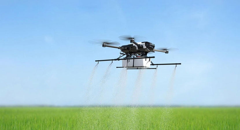
The integration of agricultural drones has revolutionised Crop Mapping, offering aerial mapping capabilities that provide unprecedented detail and accuracy. This allows for a comprehensive view of crop health, growth patterns, and areas needing attention, ensuring precise resource management and intervention.

Drone

Yield
Variability

Every farmer knows that not all parts of a field are created equal. Variations in soil type, moisture levels, and other factors can lead to differences in crop yields. Crop Mapping allows you to identify these variations and adjust your farming practices accordingly, maximizing your overall yield.

Aerial-Seeding-Drone

Resource
Management

Water, fertilizers, and pesticides are expensive inputs. Using them efficiently is crucial for maximizing profits and minimising environmental impact. Crop Mapping helps you pinpoint areas of your farm that need more or less of these inputs, allowing you to optimize your resource use and reduce waste.

Drone

Pest and Disease Management

Pests and diseases can wreak havoc on your crops if left unchecked. Crop Mapping allows you to detect early signs of pest and disease infestations, so you can take action before they spread and cause serious damage.

The capability of agricultural drones for detailed aerial mapping assists in early detection and effective management of pests and diseases. By identifying problem areas quickly, you can apply targeted treatments, reducing the spread and impact of these agricultural challenges.

Case Study photo

Regulatory
Compliance

Environmental regulations are becoming increasingly strict, and farmers need to demonstrate that they’re managing their land responsibly. Crop Mapping provides valuable data that can help you track changes in land use, monitor soil erosion, and comply with reporting requirements.

Iconic-Architecture-Expertly-Developed

How Does Crop Mapping Work?

First, we use satellites to capture high-resolution images of your fields from above. These images provide a bird’s-eye view of your crops, allowing us to identify patterns and trends that may not be visible from the ground.

Next, we use drones equipped with advanced sensors to collect detailed data from specific areas of interest. These drones can fly low to the ground, capturing data with unmatched precision.

Finally, we combine all of this data to create comprehensive maps of your fields. These maps show you everything from crop health and moisture levels to soil composition and drainage patterns.

Armed with this information, you can make smarter, more informed decisions about how to manage your farm. Whether you’re adjusting irrigation schedules, fine-tuning fertilizer applications, or planning crop rotations, Crop Mapping gives you the insights you need to succeed.