Discover the Future of Mapping: Elevate your projects with unparalleled accuracy, in-depth insights, and superior efficiency through our cutting-edge aerial mapping drone services, setting a new standard in mapping technology.
Discover Unmatched Precision with Aerial Mapping Drone Services
Imagine having a tool that allows you to measure the world with remarkable precision, almost like wielding a magic wand. Aerial mapping and drone surveying offer just that. Using advanced technology, these services capture geospatial data from an elevated perspective, revolutionising the way we map our world.
Understanding Aerial Mapping Services
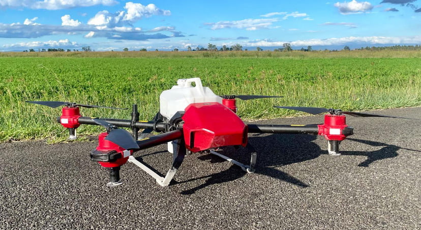
Aerial mapping, simply put, involves capturing geospatial data from above the ground. This is achieved through aircraft or specialised drones equipped with cutting-edge cameras and sensors. The perspective from the sky provides a comprehensive view of landscapes, structures, and natural features.

Concept of Aerial Mapping
Aerial mapping harnesses the power of altitude to capture data from vantage points that were once inaccessible. Drones, for instance, can effortlessly glide over vast areas, taking high-resolution images and collecting valuable data. This data is then used to create precise maps and 3D models.
Precision and Accuracy
The foundation of reliable mapping lies in precision and accuracy. Aerial mapping ensures that maps and models are as close to reality as possible. This accuracy is vital for making informed decisions in various fields, guiding progress and development effectively.
Applications of Aerial Mapping in Precision Agriculture

- Crop Health Assessment:
Imagine having the ability to monitor the health of your crops from the sky. Aerial mapping analyzes plant vigor, stress levels, and disease outbreaks, allowing farmers to take timely actions to protect their crops. - Yield Prediction and Planning:
Aerial mapping isn’t just about the present; it’s about forecasting the future. By analysing data from the sky, farmers can predict yields, plan their resources, and optimise their harvest strategies. - Irrigation Management:
Water, a precious resource, is optimised through aerial mapping. Data from above helps farmers plan their irrigation methods precisely, ensuring each plant gets just the right amount of water, promoting sustainable usage. - Pest and Disease Detection:
Early detection is key to preventing crop damage. Aerial mapping aids in identifying pests and diseases early on, enabling targeted treatments and saving the crops from potential harm.
Benefits of Aerial Mapping in Precision Agricultures
The benefits of integrating aerial mapping into precision agriculture are manifold and impactful.
- Increased Efficiency:
Efficiency soars to new heights with aerial mapping. Farmers, armed with precise data, can make informed decisions swiftly, enhancing productivity and ultimately the bottom line. - Resource Optimisation:
Optimizing resources is a hallmark of successful farming. Aerial mapping pinpoints areas that need attention, allowing farmers to use resources like water, fertilizers, and pesticides with surgical precision. - Cost-Effectiveness:
Saving resources also means saving money. Aerial mapping reduces costs by minimizing wastage, directing resources where needed, and avoiding unnecessary expenditure. - Sustainable Agriculture:
Sustainability is not just a buzzword; it’s a necessity. Aerial mapping promotes sustainable agricultural practices by aiding in efficient resource use, ultimately reducing the environmental impact of farming.

Explore Our Aerial Mapping and Precision Agriculture Solutions
At Precision Ag Services, we’re not just offering services; we’re bringing a revolution. Our aerial mapping, aerial spraying, and aerial seeding drone services provide more than data; they offer a partnership in progress. Choose precision, choose efficiency, choose the future of mapping. Your journey to superior aerial mapping begins with us. Explore now!
FAQs: Your Aerial Mapping Queries Answered
What is the primary purpose of aerial mapping?
Aerial mapping primarily serves to capture geospatial data from an elevated perspective, offering precise and accurate information for various applications such as urban planning, disaster management, and agriculture.
How does aerial mapping benefit precision agriculture?
Aerial mapping aids precision agriculture by enabling farmers to monitor crop health, predict yields, manage irrigation, and detect pests and diseases, leading to optimised resource use and increased productivity.
Are drones the only vehicles used for aerial mapping?
While drones are commonly used for aerial mapping due to their flexibility and cost-effectiveness, other vehicles like airplanes and helicopters equipped with specialised cameras and sensors are also utilised for this purpose.
Is aerial mapping environmentally friendly?
Yes, aerial mapping can contribute to sustainable practices in various industries, including agriculture, by promoting efficient resource use and reducing waste, thus lessening the environmental impact.
How can I get started with aerial mapping for my agricultural needs?
To start utilising aerial mapping for precision agriculture, reach out to specialised services like Precision Ag Services, who can guide you on how to integrate this transformative technology into your farming practices effectively.